
This project tracked the post-reproduction movements of loggerhead turtles at one of the world’s largest nesting aggregation of loggerhead sea turtles (Caretta caretta), Masirah Island, Sultanate of Oman, including investigation of clutch frequency, site fidelity, migration routes. The latter also helped to reveal intersections with threats, such as those associated with fisheries, hydrocarbon exploration, shipping and coastal development activities.
![]() Threats to marine turtles have been documented in Oman and many, if not all of the identified conservation issues remain unresolved. Pressure on Oman’s marine resources generally, and marine turtles specifically is also increasing as the country’s economy is being diversified away from hydrocarbon exploitation and into other industrial sectors such as the rapid expansion of the tourism industry. In parallel with this is an increase in population in coastal areas that has the potential to raise fishing pressure in coastal waters (where most small-scale fisheries activity is concentrated). There are therefore many challenges to the successful management of sea turtles in Oman, not least of which results from the lack of basic information about them.
Threats to marine turtles have been documented in Oman and many, if not all of the identified conservation issues remain unresolved. Pressure on Oman’s marine resources generally, and marine turtles specifically is also increasing as the country’s economy is being diversified away from hydrocarbon exploitation and into other industrial sectors such as the rapid expansion of the tourism industry. In parallel with this is an increase in population in coastal areas that has the potential to raise fishing pressure in coastal waters (where most small-scale fisheries activity is concentrated). There are therefore many challenges to the successful management of sea turtles in Oman, not least of which results from the lack of basic information about them.
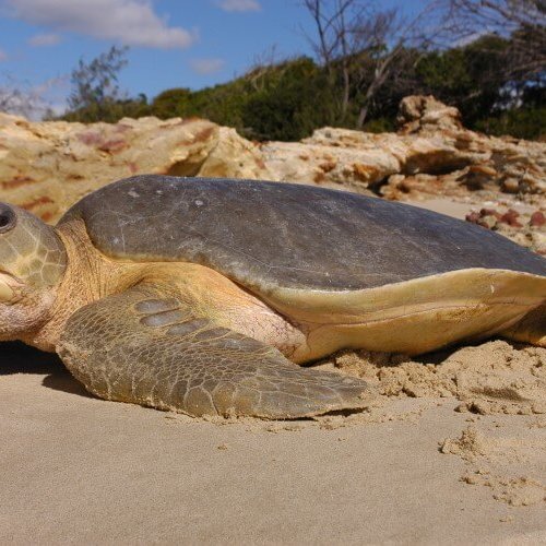
![]() There are many challenges to the successful management of sea turtles in Oman, among them the lack of even basic information about them. Dedicated research on turtles in the Sultanate has been both sporadic, unfocussed and generally conducted by untrained, inexperienced researchers. As a result, still relatively little data is available for use in conservation management planning, beyond the very basic knowledge of the location of nesting beaches. In spite of this, there is considerable national and regional awareness of the importance of Oman to nesting and feeding turtles and a desire within government to better understand and sustainably utilise the resource. This satellite tracking project addressed the need for obtaining a greater understanding of Oman’s largest turtle rookery on Masirah Island, where the loggerhead nesting population is among the largest and densest in the world. This knowledge then an be used to inform both national and international conservation needs, including assessments of the species’ global status.
There are many challenges to the successful management of sea turtles in Oman, among them the lack of even basic information about them. Dedicated research on turtles in the Sultanate has been both sporadic, unfocussed and generally conducted by untrained, inexperienced researchers. As a result, still relatively little data is available for use in conservation management planning, beyond the very basic knowledge of the location of nesting beaches. In spite of this, there is considerable national and regional awareness of the importance of Oman to nesting and feeding turtles and a desire within government to better understand and sustainably utilise the resource. This satellite tracking project addressed the need for obtaining a greater understanding of Oman’s largest turtle rookery on Masirah Island, where the loggerhead nesting population is among the largest and densest in the world. This knowledge then an be used to inform both national and international conservation needs, including assessments of the species’ global status.
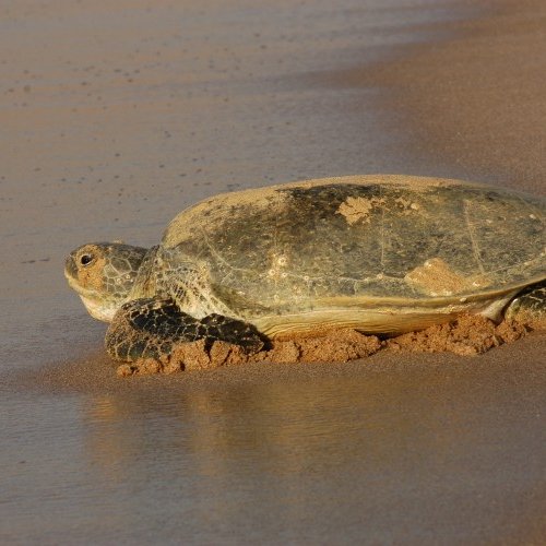
Satellite tracking devices (ST-14 Argos-linked Telonics tags) were fitted to ten turtles and the data they sent back was used to describe the turtles’ nest site fidelity, their clutch frequency (number of nests per turtle), and their return migration to foraging areas. An additional objective was to use measured clutch frequency with nest counts (obtained during beach surveys) to estimate the annual population of nesting loggerheads at Masirah. Turtles were located on the nesting beach and restrained within a 1×1.5 m plywood box. This restraint eliminated injury to the turtle and immobilized them so that the two-hour long process of tag attachment could take place. Transmitters were attached to the carapace using thin layers of fiberglass cloth and polyester resin. A silicone elastomer base to the transmitter will be used to prevent any excessive heat from masses of curing resin.
The project benefitted numerous local stakeholders, building capacity within both non-government (ESO) and government (MRMEWR) bodies that are directly involved in the project, and raising awareness among other government organisations and local communities. The project also benefitted the international scientific community with its outputs published results in peer reviewed journals.
This project was funded by the US Fish & Wildlife Service and the US National Marine Fisheries Service.
